Search -
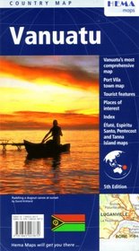
Vanuatu Country Map by Hema
Vanuatu Country Map by Hema
Author:
"Vanuatu's most comprehensive map." Folded travel map of the islands of Vanuatu. Main map distinguishes between 4 levels of roads and shows locations of accommodations, banks, hospitals and police stations. Includes a street map of Port Villa. Reverse side of map contains extensive tourist information and photos. Main map scale 1:1,000,000 with... more »
ISBN-13: 9781865003870
ISBN-10: 1865003875
Publication Date: 1/1/2007
Pages: 1
Edition: 5th
Rating: ?
ISBN-10: 1865003875
Publication Date: 1/1/2007
Pages: 1
Edition: 5th
Rating: ?
0 stars, based on 0 rating
Genres:


